Country Directory

Monday, February 2, 2015

The War in Ukraine

With the Russian-backed rebels claiming they will raise 100,000 men to fight for their cause, I thought it would be interesting to look at the 320-mile long battlefront itself. For some background on the causes of the conflict, please check out my article on the subject.

As usual, to see a larger view of an image simply click on it.

An overview of the conflict in the Donbass Region of Ukraine.

The fighting started over Crimea's annexation by Russia in March 2014. Russia claimed it because it has a majority Russian-language speaking population. Likewise, the Donbass Region has large pockets of predominately Russian speakers, and in the turmoil of the 2014 Ukrainian Revolution, groups of separatists (supported by Russia) began to take over cities in Donbass. Currently, the large cities of Donetsk and Luhansk are under rebel control, and the key city of Mariupol has also come under attack, though it remains in Ukrainian control.

The rebels have received vast amounts of money and equipment from Russia on top of the Ukrainian military supplies they've captured. Russia has also invaded Ukraine on multiple occasions; sending thousands of troops, tanks, and artillery into the country. 

I have gone through the area and found 127 visible sites relating to the war, along with 14 key airports and 23 border crossings. If you'd like to see them all, please feel free to download the Google Earth file I've made. (File [KMZ type] is hosted on Google Forums and automatically downloads.)

First, I'd like to show you Ukraine's capital, Kiev, before and during the Euromaidan protests which started the 2014 Revolution. 


Here's a wide view at all the sites in Donbass and Crimea.
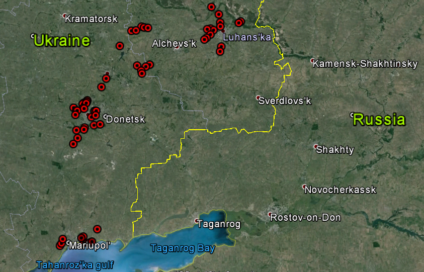
Donbass.

Crimea.

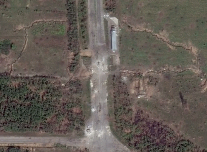
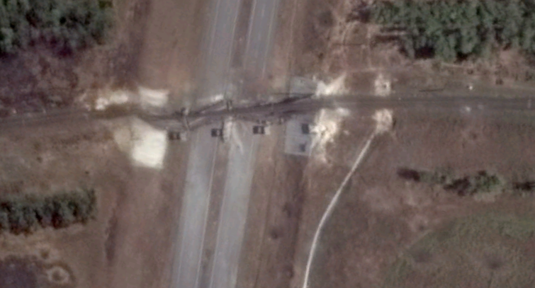
Here are some pictures of the conflict around the city of Donetsk.


Shelling damage at Donetsk Airport.

On May 26, 2014, rebels clashed with Ukrainian troops at Donetsk International Airport (which also had a military base attached). Ukraine won the initial battle but beginning in late September, rebels launched a new offensive and took control of the airport and base. 
Here are before and after photos of the military base.

Before.

After. You can clearly see burnt regions and numerous bomb craters.

Below is a comparison of the related weapons storage area.


Two damaged bridges with checkpoints. 

And finally for Donetsk, here are some trench fortifications.

Next comes Luhansk:

Fortifications and battle damage.

A destroyed bridge.

Some sites around Debal' steve:

Road block and trenches.

Fortifications.


Sites around Mariupol:

Gun emplacements.

A great example of Ukrainian fortifications and road block.

Here's some mobile artillery dug-in in Crimea.

Here are a few other images from around the Donbass Region:

This is the Druzhba Sports Facility. It was ransacked after rebels captures Donetsk. You can see part of the building is burnt out (lower side). 

This is another destroyed bridge.

Finally, the crash site of Malaysian Airlines Flight MH 17 which was shot down over rebel-held territory on July 17, 2014 killing all 298 people on board.  


Friday, January 16, 2015

Prisons of Cuba

I have found 32 active Cuban prisons as well as identified 4 other locations which may be prisons. This exclude whatever small town jails there may be. Given Cuba's population of 11.2 million, this means that there is a large prison for every 350,000 people; if we include the additional 4 "maybe's", that gives a ratio of 1:311,000. These ratios are actually better than those of the United States which has the largest prison population in the entire world.

In terms of prisons per square mile, Cuba has 1 confirmed prison per 1,337 sq. mi. There are four regions which have multiple prisons within a relatively small area: Havana, Santa Clara, Camaguey, and Holguin.

As I'll show further below, many of their prisons are located near or inside of industrial facilities. According to Human Rights Watch, as of May 2012, some 57,000 Cubans were in prison or labor camps.

Here are some maps of prison locations (click on the images for a larger view):

Locations of confirmed prisons. 

Possible prisons. 

Prisons around Havana. 

Prisons around Holguin. 

Prisons around Camaguey and Santa Clara

Here are some closeup satellite images of prisons, some of which clearly show they're part of labor/industrial complexes. 

This is Alambradas de Manacas Prison. I've marked out key features.
It's location is: 22°33'47.7"N 80°21'10.3"W

Here's a closer view of the 4 prisons in northern Santa Clara. 

This shows the two prisons at the center of the previous Santa Clara image. This particular picture clearly shows the prisons are in the industrial region of the city.

This is Jovellanos Prison (outlined in black). It too is next to a factory.
It's location is: 22°48'10.3"N 81°10'29.4"W

This prison is to the east of Havana, in the outlying town of Guanabacoa. This large prison complex covers about 93 acres, and to the far right of this image there's a factory which is very much visible. If you view the full image, you can also see that the factory is surrounded by the same fence system as the rest of the prison - this makes it abundantly clear that prison labor is being used. 
It's specific location is: 23°06'27.8"N 82°14'28.7"W

Products produced by prison labor include, furniture, clothing, and agricultural products. While prisoners are generally paid for their work, by the time government fees are taken out, the amount each prisoners receives is drastically reduced. Of course there are plenty of reports of prisoners not being paid at all. Within the Cuban prison system, there is widespread abuse and safety measures in the labor camps are basically nonexistent leading to many injuries. 

--Jacob Bogle